->

31 July 2008

Yahoo! Zimbra Maps - New! & Updated Yahoo! Local API

Yahoo! Zimbra Maps - New!

"Yahoo! Zimbra Desktop is the next-generation email application"

Easily set up Zimbra, Yahoo! Mail Plus, AOL and Gmail email accounts with the Account Wizard

Web mash-ups

  • View addresses as Yahoo! Maps
  • Automatically detect your location and find points of interest with Yahoo! Local
  • Preview web pages at thumbnails instead of opening a browser
  • See your calendar schedule from within an email message if you hover over a date
  • Web Search powered by Yahoo! is built directly into Zimbra Desktop
Larger View

Updated Yahoo! Local API
Other Yahoo Local News is that Version 3 of the Local API has been released.
One new feature is the ability to find locations along a route
Here is an example XML output
http://tinyurl.com/6xc8n9
For this map and nearest pizza restaurants
http://cartosoft.com/lab/ygeo/index.htm
"We are releasing a new version of the Yahoo! Local API (V3), that gives developers a key new feature – the ability to search for convenient points of interest for a given user defined route. For example, as you are driving from San Francisco to Sacramento, you could search for a Starbucks or for a hardware store."

The RESTful API now includes a “route” parameter that is a series of latitude/longitude coordinates, with the first pair of coordinates as the starting point and the last pair of coordinates as the ending point. A string sent as the route paramater would be structured as follows:

lat1 long1,lat2 long2,...,latn longn

The API returns XML, JSON, or serialized PHP"

Labels: , , , ,

29 July 2008

GIS Geoprocessing >Google Maps API >Google Chart API

GIS Geoprocessing >Google Maps API >Google Chart API

update2 - ESRI just announced they are adding Virtual Earth to ArcGIS
"ESRI (Environmental Systems Research Institute, Inc.) and Microsoft announced a partnership, enabling the integration of the Virtual Earth platform into ESRI’s ArcGIS Desktop and Server software. The seamless integration of Virtual Earth into ArcGIS allows ESRI ArcGIS customers access to high-quality base map layers with rich aerial and hybrid views.
Using Virtual Earth and ESRI to publish public applications will give citizens better insight into government services to ultimately inspire involvement and participation while allowing mapping developers to publish maps faster and easier."
More details
http://www.prweb.com/releases/ArcGISOnline/GIS/prweb1153954.htm


update1 - If your interest GIS Integration with online Mapping there is a Live Seminar on 31st July 2008 - "Building Mashups using the ArcGIS JavaScript APIs"
http://training.esri.com/campus/seminars/seminardetail.cfm?course_id=100

How do you make GIS Analysis work with Google Maps API online now?

Mapperz GIS Analysis - Buffer,Intersect using ArcServer & Google Maps & Chart API
Complex GIS Geoprocessing in Google Maps - data processed on the fly. Final data is assembled in a clear visual way using Google Chart API.

Behind the scenes.
Using ESRI ArcServer to buffer (see below) handrawn lines, the 'buffer' then is 'intersected' with US Population Cenus Data (2007) and Census blocks are visualised by Google Charts API.

Try Mapperz version of GIS Geoprocessing in Google Maps API and using Google Charts API

Recently ESRI have released Resource Center for ArcServer which in combination with the ArcGIS Server API's can:
"Develop custom JavaScript™ applications that mashup ArcGIS services, Google Maps, and Microsoft Virtual Earth™ data. The ArcGIS JavaScript APIs take full advantage of powerful mapping, geocoding, and geoprocessing services."

What is Geoprocessing?
The fundamental purpose of geoprocessing is to allow you to automate your GIS tasks.

So how can we prove this works online?
Mapperz's was looking up some ArcScripts (Users upload useful scripts/code) for users to download and use and modify. Found this created by Andy Gup (ESRI)
"hand drawn polyline buffer google.zip"

This contains a few files and a readme.
"This demo shows how to use a hand drawn polyline to establish a population study area buffer using ArcGIS JavaScript Extension for Google Maps API with Google base maps and drawing tools. The polyline can be edited on the fly to adjust the study area (buffer), all the calculations parameters will automatically update."

This sample demonstrates a number of things using the ArcGIS JavaScript API:
- Passing a hand drawn polyline to an ArcGIS query task
- Using a full compliment of Google drawing tools
- Using multiple queryTasks
- Use a toggle to show/hide polygons and GMarkers
- Include query info with Google Charts API and then wrapping that up in a popup information window.

The hosting web server requires IIS 6.0 and ASP.NET for this to work.
Mapperz choose brinkster.net for supporting the IIS 6.0 and ASP.NET plus live chat support if required.

Mapperz wants to thank Andy Gup for creating and making this code available to the GIS community.

The only issue found was the file 'proxy.ashx' has to have full url to 'proxy.config' to make this work. Issue reported to Andy Gup and acknowledged.

Please note this works only within US Coverage, due to using the US Census Population data (2007) - modify it if you wish for outside the USA.

Labels: , , , , , , ,

28 July 2008

State of the Map 2008 : Presentations - Open Street Map

State of the Map 2008's July 12th-13th Castletroy, Limerick has now got presentations available for people that could not attend the event.

These include:

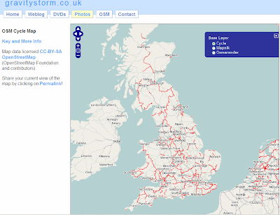
OSM Cycle Map - See how much coverage there is now and the weekly process involved.
OpenStreetMap Cycle Map
http://www.gravitystorm.co.uk/osm/

OpenRouteService - The 'driving directions' using OSM data in German (see previous post)

The State of France - Highlighting activity and where needs to be mapped.

'So I have all this data'
- Showing the numerous OSM Style's (Mapnik, OSMRender, Cycle Map) and Green Maps (Sutton & Enfield examples).

The State of Italy - Looks into the success of OSM in the City of Milan from 2007 to 2008.

MapWarper - Showing some technical details of georefencing images. (Also see http://wrp.geothings.net/)

The Commerical Viability of OpenStreetMap
- How to make money and issues highlighted with OSM data - Make it easier to use!

FreeMapIndia 2008 (part1 & part 2) - A Photo Journal of Mapping and Talking OSM in India - Part 2 shows more technical mapping aspects.

OpenStreetMap vs The World
- "iTunes for your GPS" The Comparison to OSM and Google Maps for Haywards Heath. (mentioned here by Mapperz). OSM vs Reality and 'Wrong Names', 'Missing Roads' and Wrong Spellings of Street Names.

The State of Spain (Take 2) - The continuous task of data collection and the task that lies ahead. The mention of gvSIG GIS. Highlighting that GIS is important in managing OSM data.

London Mapping Marathon - Mapping shown at small scales - London looks complete, larger zoom levels show that there is a lot of roads un-named, incorrect junctions etc. (See older post)
But also shows the huge improvement of the past year.

Using Crowd Sourced Data in a Commercial Mapping API
- Investigates the Flickr, Geonames and Wikipedia methods. Conclusion is 'crowd sourced' data can work. Positive effects for little effort.

Look out for Video and more content coming to
http://wiki.openstreetmap.org/index.php/State_Of_The_Map_2008


Related Events:
Society of Cartographers
44th Annual Summer School, Aberdeen
1-4 September 2008
http://www.abdn.ac.uk/cartographers08/
"Presentations include ones on changing coastlines, 3D panoramas, kayak mapping, and cycle mapping – with presenters including Tom Patterson (US National Parks Service), Ed Parsons (Google), Paul Hardy (ESRI) and Professor Danny Dorling (University of Sheffield). There is a very full programme that includes many interesting topics, workshops and plenty of networking opportunities"
(thanks to SteveC via email)

Labels: , , , ,

26 July 2008

Channel 4 - Big British Food Map

Channel 4 - Big British Food Map

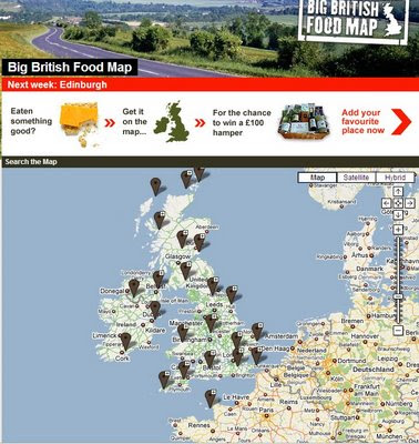
Channel 4 Big British Food Map
Channel 4 (UK TV Channel) has launched a Google Map that displays over 50,000+ places...

"
I love talking about food almost as much as I love eating food. I don’t think I’m alone in that. It’s the one topic of conversation that EVERYONE has got an opinion on. If I were to ask you to tell me about an interesting place you‘ve been to where you ate or bought something delicious, what would your recommendations be? What is so great about that place? That’s where the Big British Food Map comes in. It’s about finding and sharing those great little places that people know"
Catherine Jackson, 4Food, Channel 4

Users can add their favourite food places and maybe win a prize.

We [Channel 4] want to know about that little place you know, and why you love it. By adding a place, you could be in with a chance of winning a fabulous hamper of food. We'll be giving away one each month until November 2008.

Before you add your place, check to see if we've already got it by searching. (If it is already on the map, we still want to know what you think of it).

View the Map
http://www.channel4.com/food/big-food-map/explore-map/

Labels: , , , ,

24 July 2008

StreetCities.com - Embed StreetView with Ease

StreetCities.com - Embed StreetView with Ease

"The Street/Map control lets users easily embed a street view into any website and switch between street view and the map."


  • Display a Street View and Map in one compact control
  • Easy to customize and embed in any webpage
  • Display the current street view title and co-ordinates
  • Supports Firefox, Internet Explorer, Safari and Opera
  • Use URL parameters to modify the control appearance
  • API and source code available under Apache License for custom projects


Street Cities - Free Mapping and Street View Tools

Need to customise this?
Then http://www.streetcities.com/StreetMapAPI.aspx is your location.
Well done to Map Channels for this easy to use site.

Labels: , , ,

23 July 2008

WunderMap - Hurricane Dolly Live Tracking

WunderMap - Hurricane Dolly Live Tracking
Hurricane Dolly Radar by WunderMap
WunderMap Animates the Current Radar (Rainfall)

This is one of the best way to see a hurricane with Google Maps.
Vast amounts of data collected and represented in a fashion that the user can have as much or as little information displayed.

Below are a few options:
Webcams

Well done to the WunderMap Team,
http://www.wunderground.com/

Hurricane Dolly's current status

Labels: , , , , ,

22 July 2008

Walking Directions 'Beta' Now in Google Maps

Walking Directions Beta Now in Google Maps

Update:
'Walking Directions' option will appear when directions that are 6.2 miles (10 kilometers) or less.

Update2 - Mibazaar via Google Maps Mania finds a long detour.A 2 mile walk is now '120 mi (193 km) – about 1 day 15 hours'
http://maps.google.com/maps?f=d&hl=en&geocode=&saddr=detroit,mi&daddr=Windsor,+Essex,+Ontario,+Canada&mra=cc&dirflg=w&doflg=ptm&sll=42.482226,-82.692719&sspn=0.474992,0.85144&ie=UTF8&t=h&z=10
So Beta it is...


Google Maps Directions Car Mode
Traditional Driving Directions take you around Hyde Park, London
Map Directions (Car)
Longer Distance (3 miles but shorter time for the journey 12 mins)
**
(excludes finding parking, pay for parking and sitting in traffic waiting for parking)

Google Maps Directions Walk Mode
Switching to 'Walking' Beta Mode shows it's much shorter to Walk than Driving taking only 8 minutes longer than Driving .
Map Directions (Walking)
Shorter Distance (1 mile for the journey but 20 minutes in duration)
***
Use caution when walking in unfamiliar areas.

Official Blog Post

Labels: , , ,

UK Incinerator Map Launched

UK Incinerator Map

House Waste Incinerators Map - Existing and Potential
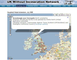
UK Without Incineration Network (UKWIN) has launched a Interactive Map that show existing and potential new sites for Household Waste Incinerators - Grey markers represent existing incinerators. Brown markers represent potential incinerators.

UKWIN, in collaboration with Friends of the Earth, has developed an interactive map of existing and potential household waste incineration sites.

"The map, which was unveiled today (July 22), documents 23 existing sites and outlines 150 locations that have been scouted for around 80 more facilities to be built and includes a table listing every facility with its location, type, capacity, operational notes and active campaign groups opposing that particular site.

Large urban areas are identified as the areas with most incineration facilities - Birmingham, London, Liverpool and Leeds all accumulating high numbers - while smaller areas such as Invergordon, Inverness, and Jersey's proposed St. Helier facility expose the range of the research undertaken.

UK WIN explains that it placed each location on the map based on facility post codes for accuracy."

Source:LetsRecycle.com

Related: Channel 4 News - 30 new rubbish incinerator plants planned for the UK


Labels: , , , , , ,

17 July 2008

The UK is watching you Google! (Building StreetView)

The UK is watching you Google! (Building StreetView)


View Larger Map
These are reported sightings of the streetview cars are mapped by readers of the 'The Register' report found via the Guardian Blog
http://blogs.guardian.co.uk/technology/2008/07/16/google_street_view_car_hoves_into_view.html

As expected the streets are getting mapped by Google, all the large cities and a few odd small locations (Ullapool,Highland in Scotland?)
is it right or is it wrong the debate rages on.
Remember there is thousands of CCTV cameras recording in the UK nobody blinks an eye. But as soon as you mention your front door been captured 'in a moment of time' everyone becomes paranoid.

Mapperz hopes Bournemouth is captured for the Dual Maps - Holiday Maps
also See Bournemouth

Labels: , , , , , ,

16 July 2008

BBC Sport's Olympic Map Released

update in blue (see below)
BBC Sport's Olympic Map Released


BBC Sport's Olympic Map 2008
BBC Sport has a nice custom maps using Microsoft Virtual Earth.
Image Source:Firefox screenshot of BBC Sport's Olympic Map

BBC Sport's Olympic map for the 2008 Beijing Games.


How to use the map
Sport icon
Yellow sport icons indicate venues
Click to find out more about a venue
Landmark icon
Blue icons indicate landmarks
Click to find out more about places in Beijing
Blog icon
Red icons indicate blog posts
Click to read an Olympics blog post
Twitter icon
Green icons are Twitter posts
Click for an update from a BBC journalist

Image Source:BBC Sport
There are more than 30 venues in Beijing.
Sailing in Qingdao on China's north-east coast.
Equestrian sports in Hong Kong, to the south.

Clicking different icons allows to find more information about venues.

• Find out more about the 37 Chinese Olympic venues

• Read articles from journalists on BBC Sport's Olympics blog

• Read Twitter updates from BBC Sport's journalists in China


The BBC would like feedback...
We would like to hear your feedback on our Olympic map - you can leave your comments on BBC Sport's Olympics blog.

This Map was created using the Virtual Earth API and Custom Maps added using MapCruncher.
If you are interested in the methodology of how this has been created here is a good starting point.
http://msdnrss.thecoderblogs.com/2008/07/16/bbc-sports-olympic-map/
"The inclement weather and a thick cloud layer over Beijing for the last few MONTHS, it has been incredibly difficult to get good satellite imagery. This makes the MapCruncher overlays a huge benefit to the application. The imagery we’re serving up was taken just a few months ago - obviously tons of progress has been made to the get the stadiums ready for August, but what a great addition to compliment the Virtual Earth platform"

View the Map
http://news.bbc.co.uk/sport2/hi/olympics/7493757.stm

Labels: , , , , ,

15 July 2008

New Google Map API Ad Icons (Experimental)

New Google Map API Ad Icons (Experimental)

Google Maps API are rolling out some changes with the Ad Manager.

New Ad Manager - Google Maps API Icons
You can now have a maximum of 10 'Advert Icons' on your custom map.

"Over the coming weeks, we're going to making a few changes to the
style of the ads rendered by GAdsManager.

Starting in version 2.119, we're going to be making two small changes. "
Mike(Google Employee)

(make that 3)

  1. replacing the current white pushpin style with a new style where the ads will appear to be flat "on the map. see example image
  2. "nudging" the ads slightly, so that ads will no longer ever sit on top of any text rendered in the map tiles.
  3. also starting to serve ads outside the USA
Mapperz can show an example that is working in the UK.
http://mapperz.googlepages.com/ads_manager_test.html
(If you don't see new icons displayed - try zooming once or panning the map - please remember that it is experimental!)

The one issue that you can clearly see at present is the icons still overlap text on the map tiles.
(this is due to the the tiles being rasters, to solve this google would new to vectorize the text as a bounding box and buffer the vector rectangles to create 'avoid ad/text clashing polygons'.
A tip from cartographic text placement there.)
VectorMagic does a very good job (Sample)

Here is an new icon
http://pagead2.googlesyndication.com/pagead/imgad?id=CIXc9e63iK6PywEQEBgQMggWzfQHA9oWTQ
and another
http://pagead2.googlesyndication.com/pagead/imgad?id=CPOInt6BsJf1IhAQGBAyCGKbz0m-eFN1
(looks like each ad has its own id for adwords purposes.)

How do you enable?
Not everyone wants to have 'Google Ads' on there maps so it's an option to include it.

var map = new GMap2(document.getElementById("map")); //Add the Map
map.addControl(new GLargeMapControl());//Add the Large Control
map.setCenter(new GLatLng(37.423148, -122.084874), 13);//Centre on LatLng
var ads_opts = { //Add Ad Options
mode: "experimental", //Mode:Experimental -Subject to change
maxAdsOnMap: 10 //Maximum number of Ads (10 is Max)
};
var adsManager = new GAdsManager(map,
"google", ads_opts);
adsManager.enable();

"google" will be where you put your adsense id so any click through would be registered
to your account


Official Example
http://gmaps-samples.googlecode.com/svn/trunk/
adsmanager/adsmanager_new.html

Source:
http://groups.google.com/group/Google-Maps-API/browse_thread/thread/12534906310673ff#
Mapperz New UK Version
http://mapperz.googlepages.com/ads_manager_test.html

Labels: , , , , ,

10 July 2008

ArcGIS JavaScript Extension for the Google Maps API

Updated see red and blue below

ArcGIS JavaScript Extension for the Google Maps API
"The ArcGIS JavaScript Extension for the Google Maps API allows you to use your ArcGIS maps and tasks in the framework of Google Maps. There are many reasons to use this extension to expose your GIS data. Perhaps your audience already knows how to use Google Maps. Perhaps you're already familiar with the Google Maps API. Or maybe you just like the look and feel of the Google base maps."

Google Maps + Powerful GIS Analysis
ESRI GMAP API Directions with profile UK
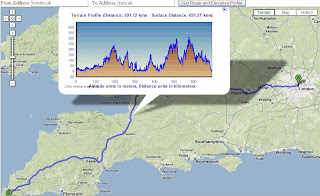
Here is a Google Maps Direction Route - with the added profile of the route generated by ArcServer. (click image to see live example)

Here is another example of adding GIS capabilities to Google Maps.

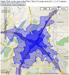
ESRI Google Maps API DriveTime
Drive Time Polygons (1,2 & 3 minute driving time polygons) on the fly - overlaid on Google Maps. (click image to see live example)
Custom version http://mapperz.googlepages.com/DriveTime_ESRI_GMAP.html
(Drive Time only works in the US and Canada)

How is this geo-processing action created?

Create Drive Time Polygons - ArcGIS Model
Image source: http://globe5.arcwebservices.com/arcgisoutput/Network_ESRI_DriveTime_US/CreateDriveTimePolygonsDisks.htm

ArcGIS comes with Model Builder here geoprocessing functions Make Service Area Layer, Add Locations are just some of the core processing elements to create Drive Time Polygons.

This is the start of some serious and powerful tools that will and can be built on to 'enrich' the map user.
This provides them with detailed information that can be manipulated and customized to the users specifications on the fly.

Other possibilities at the Geo-Processing Service examples here
  • Display your own maps on top of a Google Maps base map.
  • Execute a sequence of GIS models and display the results in Google Maps.
  • Search for features in your GIS data and display the results on Google Maps.
  • Find addresses using your own address locator and display the result on Google Maps.
  • Display attributes from your GIS data on the map using the Google Chart API.
  • Allows others to add GIS functionality from your server as a Google Mapplet.
The future looks bright with GIS software companies taking on popular mapping API's

Please note there is an ArcGIS JavaScript™ Extension for Microsoft Virtual Earth™ version as well.

Reported by Google Map Mania from this Blog


Labels: , , , , ,

09 July 2008

Open Route Service using Open Street Map Data

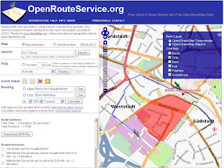
OpenRouteService.org is taking OpenStreetMap Data and making use of the Street Data and creating Full Descriptive Routes from it.

*Currently only for Germany
Open Route Service Fastest Route
Blue Line represents the calculated 'fastest' route. Summary and full 'turn by turn' directions
Open Route Service Fastest Details in German
Currently in German but gives you full turn by turn directions.

"
Routing services are probably the most important application for street data - apart from visualizing them on a map. While there are a range of desktop (or even mobile) applications that can provide such functionality also in combination with Open Street Map data, we focus here on an approach based on the concept of interoperable Service Oriented Architectures (SOA). These are regarded as an important concept for forthcoming software architectures in general, and more and more being applied also in the GI (geographic information) sector."

Polygon Avoidance Areas
Open Route Service Fastest Avoid Polygon
The same route as above though this time a digitized polygon (red area) defines an area for avoidance, the route is processed in less than 3 seconds.

Try it here
http://data.giub.uni-bonn.de/openrouteservice/index.php


Data Sources
OpenStreetMap
Internal use of Germany Five-Digit Zip Code from ESRI Data & Maps 2003 for Geocoding

Created by http://www.geographie.uni-bonn.de/karto/

Labels: , , , , ,

03 July 2008

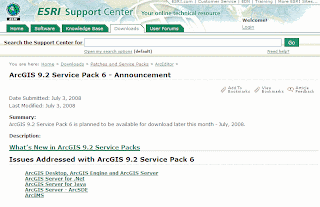
ArcGIS 9.2 Service Pack 6 - Announcement

ArcGIS 9.2 Service Pack 6 - Announcement

So you just got 9.3?
Now you can fix you 9.2 with Service Pack 6.

Confused? Users are.
Which is the most up-to-date? Which is the more Stable?

ArcGIS 9.2 Service Pack 6 Announcement

ArcGIS 9.2 Service Pack 6 is planned to be available for download later in July, 2008

Might be worth the wait until 9.3 SP1 if some of these are missed in the released version.

9.2 SP 6 fixes - Mapperz quick pick

NIM006823 - When zooming in and using the Identify tool during a redraw, the values returned are NoDATA.

NIM007248 - ArcMap hangs when adding a field to a shapefile after using the Select by Attributes dialog box and leaving the dialog box open

NIM007810 - Construct Features tool fails with error message "Failed to construct features" when attempting to construct polygons from lines

NIM011023 - Deleting or renaming a Cartographic Representation from a feature class causes ArcMap to crash when opening a .mxd

NIM032774 - Group elements in the data frame and in annotation may disappear when editing is projected on the fly.

NIM033517 - When using Select By Location to process a large dataset, the following error may display: An unexpected error occurred in the Select By Location command

NIM034793 - ArcMap crashes when tracing around a large dataset.

NIM035777 - Features disappear when selecting features with the Select Features tool from a layer (shapefile or geodatabase)

NIM034395 - A JPEG with a non-standard header does not display correctly at 9.2.

Windows Vista Woes

NIM032480 - Windows Vista only: Viewing metadata in ArcCatalog and exporting metadata using the Export Metadata dialog box in ArcCatalog fails with Vista SP1

NIM032629 - Windows Vista only: Unable to delete more than two fields from a shapefile in the same ArcMap session. The shapefile is locked after the second field is deleted.

NIM033840 - Windows Vista only: Using the ESC key to cancel drawing of large datasets in ArcMap can render the application unresponsive until the drawing is complete

Careful connecting to 9.3 geo-databases

NIM034190 - An Upgrade message still appears in ArcCatalog when connecting from a 9.2 client to a 9.3 geodatabase. When a 9.2 client dismisses the message box, the next time a 9.3 client connects, the geodatabase must be upgraded

Built-in Help
NIM034715 - Updated help files to fix typos, broken links, and software changes.

http://support.esri.com/index.cfm?fa=downloads.patchesServicePacks.viewPatch&PID=17&MetaID=1406

Labels: , , , ,

02 July 2008

Satbeams Map

Satbeams Map

Satbeams Generates Transparent Polygons
Satbeams generates transparent polygons on the fly for each selected satellite 'beam'.

Satbeams Signal Strength Map
This example shows signal strength (useful for finding out receiver dish/antenna size)
http://www.satbeams.com/footprints?beam=5223


"The site allows to view the Satellite Coverage maps for most of the satellites all over the globe in Google Maps format. At the same time it is possible to place markers on the map stating which frequencies/channels one can receive at the specific location and view what others can receive from the selected satellite in different places of the world."
Alexander -Satellite Coverage Maps

Current stats (subject to expanding numbers)

Number of Satellites: 226
Coverage maps: 641

Number of receivers: 4933
Number of Antennas: 289
Number of LNBs: 416


Registered Users have more
  • Save markers on the map and report which satellites and beams one can receive there
  • See the markers saved by other members (perhaps there is someone already receiving selected Satellite/Beam in the neighbourhood)
  • Add Satellite equipment to the reception report including the antenna model, receiver and Lnbs (Low-noise Block Converter)
  • Report different news - frequencies, channels and even new equipment (i.e. receivers, dishes, Lnbs...)
As a result, the more people place markers with their reports the more accurate information is available to Sat-TV users all over the globe.

Mapperz notes there was a lot of work done on the website - it took
several months of several people to make the website.
More features to come in a 2-3 months from now. So stay tuned.
Congratulations to the team for creating a useful mapping tool.

related:
http://www.dishpointer.com/
http://mapperz.blogspot.com/2007/08/satellite-finder-map-updated.html

Labels: , , , , ,

ArcGIS 9.3 Web-based Help Now Available

update 02/07/2008 (7pm)

best and worst of the Help

Great to see the ArcGIS 9.3 Help up and running for all users now.

One thing I have noticed is the ‘Geoprocessing Center’ promised is either late coming or still out of date…(anyone know anymore?)

http://mapperz.blogspot.com/2007/06/esri-users-questions-answered.html

The best updated function so far is the 'Near' Command (ArcInfo Only)
Supporting Input points,lines, polygons and multipoint.
(a long time request)

http://webhelp.esri.com/arcgisdesktop/9.3/index.cfm?id=1273&pid=1268&topicname=Near_(Analysis)

old version only supported points as an input

http://webhelp.esri.com/arcgisdesktop/9.2/index.cfm?id=1111&pid=1107&topicname=Near_(Analysis)

Mapperz (via the James Fee 'Spatially Adjusted' Blog Comments

ArcGIS 9.3 Web-based Help Now Available


ESRI finally have updated their Support pages with 9.3 web-based Help

Quick picks

PDF Support (Acrobat 9.0)
(export with layers and attributes)

Postgres Connection
(via ArcSDE)

ArcGIS 9.3 Shortcuts

Animation of Data

And finally ArcGIS understands nominal scales!
(wiki)

so now One inch = 5 miles works. (thank you ESRI)


ESRI 9.3 Help now 'out of beta' and available for all to view and use.

New Features and Helpful 'error' messages have plain English explanations

http://webhelp.esri.com/arcgisdesktop/9.3/index.cfm?TopicName=welcome

The final build number for ArcGIS 9.3 is Build 1770
via Mandown (NZ)

Labels: , , , , ,