->

29 April 2010

Ordnance Survey Maps Vector Map District Available

Ordnance Survey Maps Vector Map District Available


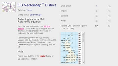
Finally a very useful dataset from ordnance survey for users wanting to create cartographic maps at mid-scale. Licence favourable for the use (with source attrbution) for the like of open street maps and others.

Techie spec.
Specification OS VectorMap District
CoverageGreat Britain ( England, Scotland and Wales )
Data sourceMajority of content derived from the mid-scales database. Buildings, cartographic text and functional sites derived from large-scale database.
Data structureESRI® Shape
ScaleNominal scale is 1:25 000.
Recommended scale range is 1:15 000 to 1:35 000.
Storage (unzipped)Tiles range between 6 - 20 Mb
Vector stylingShape format is supplied without styling, enabling users to customise the data to suit their needs.
Product content

Each vector feature has its own feature code, and falls within one of 15 layers:

A full list of feature codes and layers can be found here.

Number of tiles2860 tiles cover Great Britain
Tile size10km x 10km
Coordinate reference systemOSGB36. (@mapperz will have a WGS84 version by May2010)

Data Available to Download Here:
https://www.ordnancesurvey.co.uk/opendatadownload/products.html

Labels: , , , ,

23 April 2010

Magnificent Maps - Free Exhibition - British Library

Magnificent Maps - Free Exhibition - British Library (London,UK)

OPENS FRIDAY 30th APRIL 2010 : seven days a week : admission free :D

Magnificent Maps British Library London UK
"Maps can be works of art, propaganda pieces, expressions of local pride, tools of indoctrination… Magnificent Maps brings together 80 of the largest, most impressive and beautiful maps ever made, from 200 AD to the present day."
Website
http://www.bl.uk/magnificentmaps/

source: http://britishlibrary.typepad.co.uk/magnificentmaps/2010/04/press-coverage-roundup.html

Labels: , , ,

22 April 2010

Unlock Places API - Geo Data Finder

Unlock Places API - Geo Data Finder

"The Unlock Places API was recently upgraded to include Ordnance Survey’s Open data. This feature rich data from Code-Point Open, Boundary-Line and the 1:50,000 gazetteer includes placenames and locations (points, boxes and shapes) and is now open for all to use"

Unlock API Map OSM

Results Clearly displayed on Open Street Map using the API.

Unlock services are middleware, which means they're intended to be used by another application- a script, or a web site.

Unlock places gazetteer search can be used in "real time" - looking up the coordinates of postcodes to search against your own database - or in "batch mode", using the gazetteer to georeference a large collection of media files.

Unlock API Examples

Display in Google Earth - Image http://unlock.edina.ac.uk/map.html

Example Request:

http://unlock.edina.ac.uk/ws/nameSearch?name=edinburgh&format=html

You can see the results in different formats by using a different format parameter

  • 'html' to see results on a web page, with individual features on a map
  • 'kml' to see KML data suitable for import into Google Earth
  • 'json' for a Javascript Object Notation suitable for re-use in web applications
  • 'xml', which is the default option.

Other Output formats:

  • GeoJSON
  • GeoRSS
  • TXT
More Examples and More Detials on the API

http://unlock.edina.ac.uk/queries.html#examples

http://unlock.edina.ac.uk/api.html

Get Started: http://unlock.edina.ac.uk/getstarted.html

source :http://unlockdata.wordpress.com/2010/04/21/unlock-places-api-version-2-2/

Labels: , , , ,

21 April 2010

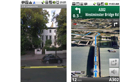
Google's FREE Navigation killer - now released for the UK

Google's FREE Navigation killer - now released for the UK ( & Ireland)

Google's FREE Navigation Killer
Image:The Guardian

http://www.google.com/mobile/navigation/

Killer Features:

  1. FREE
  2. Voice Commands
  3. Traffic Indicator (Red Slow/Stop, Yellow, Green Go.)
  4. Map, Satellite and Streetview modes
  5. There are already upwards of 50 million people using Google Maps.

Full Article by Jemma Kiss
http://www.guardian.co.uk/media/pda/2010/apr/21/digital-media-google

Download Google Maps Navigation
http://www.google.com/mobile/navigation/

Labels: , , , ,

20 April 2010

London Marathon Map 2010 - Now with StreetView

London Marathon Map 2010 - Now with StreetView

Racing starts 9.00am BST on Sunday 25th April 2010

9am Elite Women's Race Starts
9.25am Wheelchairs Race Starts
9.45am Elite Men's Race Starts
9.45am Mass Race Starts

London Marathon Map 2010 - Now with StreetView
Runner and Spectators can use the map to find locations around the course.
Use the interactive Timeline Bar to find out when lead runners go past.
Streetview is available now to view the location also.

London Marathon Map 2010 - Legend
Look out for Crowd Density Mapping - live on the race day

http://www.virginlondonmarathon.com/interactive-map/


Road Closures [pdf]
http://static.london-marathon.co.uk/downloads/pdf/road_closures_2010.pdf

improvement on last years map (2009)
http://mapperz.blogspot.com/2009/04/london-marathon-maps-2009.html

Labels: , , , ,

16 April 2010

Radar Virtuel European Airspace Map

Radar Virtuel European Airspace Map

Update: Now preset with the Volcano Ash Cloud Plume Layer

Volcano Ash Cloud Plume Map Layer
The grey zones represent the approximate area that the ash cloud from the Icelandic Volcano is in near real-time.


Radar Virtuel European Airspace Map
The Map says it all - No (or very limited) Flights in Northern Europe

Due to a volcano in Iceland the Eyjafjallajokull (pronounced "ay-yah-
FYAH'-plah-yer-kuh-duhl") glacier is producing a huge cloud at high altitude of ash that is covering large areas of Northern Europe restricting air travel.


View the 'Non' Air Traveling Map - http://www.radarvirtuel.com/
(site has been busy and might be slow today) - A Live Map

Labels: , , , ,

15 April 2010

FIND - First Land Registry Advanced Online Mapping Website

FIND, an advanced online mapping website, has launched a unique service, which enables users to order Land Registry documents via a map interface.

Find - Land Registry documents via a map interface
Find existing Land registry documents by Map


"FIND, the UK's most advanced online mapping website, has launched a unique service, which enables users to order Land Registry documents via a map interface. This exclusive facility, designed for commercial organisations offers significant time and cost savings for property, environmental and conveyancing professionals. The system works by using maps instead of exact addresses to determine land ownership. FIND allows users to select a map location, zoom into the area of interest - without an exact address – and then highlight a specific area to search. The site then displays Land Registry Title Registers and Title Plans, which can be ordered individually or in bulk, saving both valuable research time and the need to submit multiple document requests for the same area. This application is particularly useful for sites that cover large areas and have multiple occupancy or unclear owner identification. FIND users can also opt to order multiple documents at the same time."

Find - Land Registry documents via a map interface options
Users can define a search area directly on an Ordnance Survey map for Land Registry title documents.

http://www.findmaps.co.uk/

Labels: , , , ,

14 April 2010

Society of Cartographers Newsletter April 2010

Society of Cartographers Newsletter April 2010

Fully packed with News from the UK Cartographic Society

Society of Cartographers April 2010
Includes:
  • Geology Digimap
  • The British Library – details of a major map exhibition
  • Summer School - University of Manchester (8 - 10 September 2010)
  • Map2 – the zoomable map on paper
  • UK Web Archive (about some UK blog...)
  • Crisis Mapping - Open Street Map
  • Cartographic Ramblings
  • In the News
  • Events
  • New Members
  • Awards
Society of Cartographers April 2010 - OSM
SoC Newsletter out steev8's ramblings, crisis mapping, BL map exhibition details, surgical sieve, 2010 summer school info... and more.

http://www.soc.org.uk

http://www.soc.org.uk/newslett.htm Archive PDF's

Labels: , , , , ,

12 April 2010

The Beauty of Maps - BBC Series

The Beauty of Maps - BBC Series
"Seeing The Art In Cartography"
An amazing array of interesting cartographic maps spanning centuries of maps that changed the perception of the world we see today.

Psalter 1260 Map

http://www.bbc.co.uk/bbcfour/beautyofmaps/historical_maps.shtml#/psalter/intro/

Desceilers World Map 1550

http://www.bbc.co.uk/bbcfour/beautyofmaps/historical_maps.shtml#/desceliers/intro/

Digital World Internet Data Movement Map

http://www.bbc.co.uk/bbcfour/beautyofmaps/digital_worlds.shtml#/digital-worlds/highlights/global-data-exchange/


Clips can be previewed (UK only? iplayer restricts uk only - advise foxyproxy & a uk proxy)

*Can be seen on BBC Four in the coming weeks or on the BBC iPlayer

1/4. The story of the Hereford Mappa Mundi, the largest intact Medieval wall map in the world.
Next Monday 19th April, 20:30 BST on BBC Four
Medieval Maps - Mapping the Medieval Mind

http://www.bbc.co.uk/programmes/b00s2w83

Beauty of Maps main page
http://www.bbc.co.uk/bbcfour/beautyofmaps/index.shtml

Also see 'Animated History of European Mapmaking'
http://www.bbc.co.uk/history/interactive/animations/map_making/index_embed.shtml

Look out for "Windows on the World" [starts Sunday 18 April 2010 21:00 BST BBC4 & HD]
"In a series about the extraordinary stories behind maps, Professor Jerry Brotton uncovers how maps aren't simply about getting from A to B but are revealing snapshots of defining moments in history and tools of political power and persuasion."

http://www.bbc.co.uk/programmes/b00s2wvh
(thanks for the reminder from @steev8)

source: @mapperz

Labels: , , ,

08 April 2010

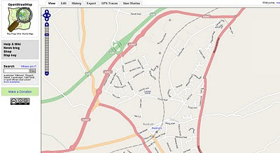
OSM edits with OS Streetview 10k Rasters

OSM edits with OS Streetview 10k Rasters (GB only)

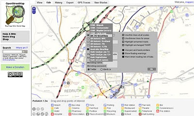
This layer is now in the main OSM editor (Potlatch) on http://www.openstreetmap.org
switching to 1:10,000 UK:Streetview Raster Background in Open Street Map Editor

Before you go to far please read this
http://wiki.openstreetmap.org/wiki/Ordnance_Survey_Opendata

take note of:

When tracing over OS StreetView

  • When everything is derived from OS StreetView source=OS_OpenData_StreetView
  • When just the name is derived from OS StreetView source:name=OS_OpenData_StreetView

When adding OS vector data

Choose an appropriate tag for the object based upon the OS OpenData product. For example source=OS_OpenData_Boundary-Line

OS OpenData StreetView OSM editor Potlatch
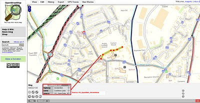
OSM edits with OS StreetView 10k Rasters - adding a Residential Road.

OS OpenData StreetView OSM Potlatch Redruth
http://www.openstreetmap.org/?lat=50.23952&lon=-5.22222&zoom=15&layers=B000FTF

Redruth, Cornwall has always been a bit thin on the ground with OSM data but the Ordnance Survey Open Data Rasters (re-projected)to WGS84 can now help as a background to trace. If tracing from OS Rasters please use the tag source=OS_OpenData_StreetView (if both Name and Road have be derived from OS opendata)
if just the name source:name=OS_OpenData_StreetView

source & thanks to: http://twitter.com/richardf/statuses/11754544110
OS StreetView is now in #osm potlatch editor at zoom levels 15/16 - just click the options icon and select 'OS StreetView'

Labels: , , , , ,

07 April 2010

Digimap for Schools

New Digimap® data supply service for GB Schools
GB (Great Britain England, Scotland & Wales) but not Northern Ireland Schools

updated 8th April with correct details - many thanks to Emma Sutton (Geoservices Support Coordinator) EDINA
Ordnance Survey please update your PDF the right details.
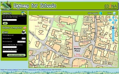
Digimap for Schools
Schools will be able to print A4 or A3 Maps from the Online Service coming soon. Teachers will be able to teach children the importance of maps in a much easier 2011 fashion.

http://digimapforschools.edina.ac.uk

So this is why 1:25,000 Explorer Maps & 1: 50,000k Landranger Maps are not part of OpenData from Ordnance Survey.

Cost:
£60 for primary schools, and from £75–£125 for secondary schools.
  • Includes Ordnance Survey's OS MasterMap®, the most detailed mapping available for Great Britain, with over 450 million features from the built and natural landscape such as building outlines, pavement edges, walls and fences, house numbers, ground cover, benchmarks and much, much more.
  • Offers complete coverage of Great Britain mapped at 1:10 000 scale and showing street names.
  • Provides a seamless digital map covering all 403 sheets in the OS Explorer Map series (1:25 000 scale), all 204 sheets in the OS Landranger Map series (1:50 000 scale) and regional maps at 1:250 000 and 1:1 million scales.
  • Includes map keys and a search gazetteer with over 250 000 place names.
  • Maps can be located using postcode or place name searches, with a series of progressively more detailed map views available.
  • Maps can be titled by users before printing at either A4 or A3 size in portrait or landscape format.
  • Map content is updated annually.
  • Unlike paper maps, digital maps can be centred on your school or place of interest.

"The web interface gives a generous map area and has been designed to so that pupils can easily find maps themselves. Digimap for Schools supports maps skills teaching in geography, and has many wider cross-curriculum uses. It is the next step for pupils and teachers who generally use paper maps but are now looking for the flexibility of using digital mapping within a safe-surfing environment."

Digimap for Schools is designed to provide access to mapping, but is not a GIS.
Digimap for Schools is available via subscription for an annual charge of £60 for primary schools, and from £75–£125 for secondary schools.
Free trials available, sign up and more information at http://www.jcs.nen.gov.uk/catalogue/digimap.html

Map skills are also included as a key skill in the new Primary Curriculum, due for implementation in England from September 2011 under ‘Historical, geographical and social understanding’. Use of maps is considered to be ‘essential knowledge’ for developing understanding of how and why places and environments develop, how they can be sustained and how they may change in the future.

source: [big PDF with some image errors]
http://www.ordnancesurvey.co.uk/oswebsite/education/mappingnews/previouseditions/ed37.pdf [outdated]
info
http://www.jcs.nen.gov.uk/catalogue/digimap.html
more info
http://digimapforschools.edina.ac.uk/cosmo/faqs

Labels: , , , , , , ,

05 April 2010

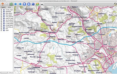
OSM compare with OS Opendata Meridian2

OSM compare with OS Opendata Meridian2

update3:

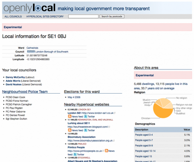
Also Openlylocal is using the OS Opendata Postcodes
Openlylocal.com

http://countculture.wordpress.com/2010/04/06/new-feature-search-for-information-by-postcode/

update2 : Geocode Great Britain Postcodes >> http://www.uk-postcodes.com/ (not Northern Ireland) in HTML, XML, CSV, JSON or RDF formats. [now improved]

update at bottom: OS Streetview(10k rasters) with OSM in WGS84 (latitude, longitude like google,bing multimap maps)

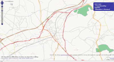
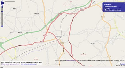
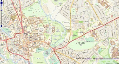
View OpenStreetMap tiles and the new Ordnance Survey OpenData Meridian 2 tiles.
(but go with Meridian2 now or wait for VectorMap District next month?)

OSM compare with OS Opendata Meridian2
Redruth could be improved with the import of Meridian2 data - but is it worth waiting for the New OS Dataset 'VectorMap District' due in May 2010?

Meridian 2 Scale
"
The product is typically viewed at 1:50,000 and at this scale the generalisation of its features maintain geometric integrity and accuracy."


OSM compare with OpenData Meridian2

Traditional Open Street Map tiles can Meridian 2 help improve the more rural areas with many missing roads?

Compare the maps yourself woth the slider in the top left corner.
http://gibin.geog.ucl.ac.uk/~ollie/osopendata/meridian/?zoom=14&lat=50.23598&lon=-5.2233&layers=BT

[Very helpful and quickly set up]


May2010 - sample data is now available for
Bath (SP76) & Milton Keynes (SP83)
VectorMap District format and scale
Raster (lzw tiff)
Nominal scale is 1:25 000.

Recommended scale range is 1:20 000 to 1:30 000.

Vector (ESRI Shapefile)
Nominal scale is 1:25 000.
Recommended scale range is 1:15 000 to 1:30 000.


"
Coming soon – mid-scale customisable mapping

May 2010 will see the launch of OS VectorMap District, a customisable map that you can style to meet your own specific needs. What's more it will be available to use as part of the OS OpenData initiative!

OS VectorMap District provides a backdrop against which other datasets, together with your own information, can be overlaid. OS VectorMap District provides a great combination of high-quality data with the freedom to show the content you want, in the way you want to show it.

OS VectorMap District will be available in both raster and vector formats, so you can use it “out of the box”, or customise the look and feel to meet your specific needs. The vector format is supplied as points, lines, polygons and text, and includes 35 different types of feature code. This allows you to select and style different features in different ways."

More details

http://oliverobrien.co.uk/2010/04/accuracy-vs-completeness-osm-vs-meridian/

Ordnance Survey Streetview (Rasters) with Open Street Map

Ordnance Survey Streetview (Rasters) with Open Street Map (Development)

http://edgemaster.dev.openstreetmap.org/streetview_tiles/ossv.html?zoom=15&lat=51.75539&lon=-1.2401&layers=BTF


Labels: , , , , , ,

03 April 2010

ESRI Resource Centre - New

ESRI Resource Centre - New
or Center

ArcGIS 10 resource centre open

http://resources.arcgis.com/

ArcGIS 1o products included (intentionally?)

ArcGIS 10 includes a redesign of the ArcGIS Desktop interface and additional and improved functionality throughout the ArcGIS product line.

The following sections summarize changes in the software in different functional areas. Each section includes links to topics with more information for that specific area of the software.

Documentation

The resource centers and Support Web sites are merged into a single Web site and user experience.

Product documentation is reorganized and improved.

  • Over 75 percent of the help has been rewritten and updated.
  • Topics have been organized based on skill sets. The Essentials library contains core GIS concepts. The Professional library contains information about software functionality, how to use it, and more advanced GIS concepts.
  • The Administrator library contains information for people who install software, manage licensing, and administer servers and databases. The Developer library contains information for people who want to customize ArcGIS, create their own custom applications, or access data outside of ArcGIS clients.
  • Workflows and tutorials have been added to the ArcGIS installed and Web help.
  • The installed help files take up less space on your computer.
  • Videos have been added to the Web help.
example :
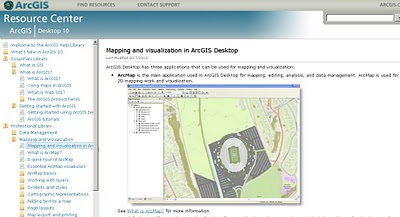
Mapping and visualization in ArcGIS Desktop

http://help.arcgis.com/en/arcgisdesktop/10.0/help/index.html# /Mapping_and_visualization_in_ArcGIS_Desktop/00660000042t000000/

Deeper Examples:
Exercise 1: Learning the fundamentals of representations
http://help.arcgis.com/en/arcgisdesktop/10.0/help/index.html#/Exercise_1_Learning_the_fundamentals_of_representations/008t00000073000000/

source:
http://geo.geek.nz/esri/redesigned-esri-support-centre-website-now-available/

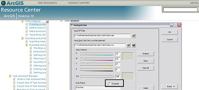
and a surprise Overprinting is now supported!
(after 8 years of asking)

Spot Tool overprinting

ArcGIS 10 supports overprinting via the Spot Color tool. This allows you to create color-mapped .eps files for a series of map sheets that use the same set of colours.

Labels: , , , , , , ,

02 April 2010

Surrey Embraces the Open Data Initiative

Surrey Embraces the Open Data Initiative
(Open Street Map gets High Resolution Aerial Photography)

osm_mapper ITO World

Surrey Heath Borough Council and ITO World are proud to announce the first release of high resolution aerial photography, for all of Surrey, UK, to OpenStreetMap under an open licence that allows reuse.

The idea came to James Rutter, GIS Manager for Surrey Heath,
“we created most of the OpenStreetMap data for Surrey Heath, and it struck me that if we had high resolution aerial imagery then many more people would contribute.”

The project also has the financial backing of nine other Surrey districts: Epsom and Ewell,Elmbridge, Guilford, Mole Valley, Runnymede, Spelthorne, Tandridge and Woking. All of
whom will benefit from processed aerial imagery tiles that can be used internally, and the imagery will also be available to OpenStreetMap users so they can contribute to a better
map of Surrey.

There are multiple benefits to be gained by Local Authorities working with OpenStreetMap,
such as a more democratically made map with instant updates. James Rutter said, “we
wanted to start mapping details that were relevant to our local communities, not just what data providers feel is worth mapping. We can edit OpenStreetMap and see the updates
almost instantly, the Ordnance Survey raster products take months for new releases. By doing this we are also making a high quality map base available for all communities in Surrey, with data that we have checked for accuracy.”

ITO World are providing services to allow authorities to monitor and review the accuracy of
contributions to OpenStreetMap for their local area. Christopher Osborne of ITO, says
“OSM Mapper has thousands of users globally, and a growing number of Local Authorities
are using it to engage with the OpenStreetMap project. We provide OpenStreetMap tiles
for websites, but now we are being asked how to crowdsource improvements to data, such as changes to roads and bus stops.” OSM Mapper is a free online product, developed with the support of Ideas In Transit, a five year research project funded by the UK Government.

High quality aerial imagery has been proven to be an extremely effective resource when creating detailed mapping. After the Haiti earthquake, satellite photography was released under an open licence by GeoEye and DigitalGlobe, which resulted in a detailed map of Haiti within days. ITO World visualised the story of ʻOpenStreetMap: Project Haitiʼ, for Sir Tim Berners-Leeʼs talk at this yearʼs TED conference. The visualisation provides a vivid story of how thousands of volunteers from the OSM community were able to create the most comprehensive map of Haiti, using the imagery.

Peter Miller of ITO World, says “the Government's commitment to opening up official data and the imminent release of various Ordnance Survey datasets, under an open license is a very significant development. We are confident this will to lead to considerable innovation to the benefit of the UK economy and its citizens.”


Links:
http://twitter.com/osbornec
ITO World - http://www.itoworld.com
MySurreyHeath - http://isharemaps.surreyheath.gov.uk/mySurreyHeath.aspx
OSM Mapper - http://www.itoworld.com/static/openstreetmap.html

Labels: , , , ,

01 April 2010

Download Ordnance Survey Data

Download Ordnance Survey Data

updated (servers now active & running!)

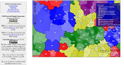
Pretty Postcodes
Code-Point Open

Codepoint Open - OSM Rendered

http://random.dev.openstreetmap.org/postcodes/?layers=000F0F0FBT
(development - may change at anytime)

Problems downloading on the OS OpenData site?
Alternative site: http://parlvid.mysociety.org:81/os/
Donate if you can (thanks)

now includes:
Code-Point Open
  • NationalGrid ↔ WGS84: AGPL Perl code, GPL PHP code
  • CSV headers: Postcode, Quality, PO box indicator, Delivery points stuff x 7, Easting, Northing, Country, NHS region, NHS health authority, County, District, Ward, Postcode.
  • WGS84 edition – with latitude and longitude instead of National Grid, and empty columns removed (so CSV headers are: Postcode, Quality, Latitude, Longitude, Country, NHS region, NHS health authority, County, District, Ward).
:) thanks @jonobennett

OS Meridian2 xml_rendered in OSM Mapnik
Fast implementation above Meridian2 rendered in OSM Mapnik

Another mashup using the OS 50k Gazetteer
A Tour of the OS 50k Gazetteer Linked Data
http://www.ldodds.com/blog/2010/04/a-tour-of-the-os-50k-gazetteer-linked-data/


Ordnance Survey Open Data


Ordnance Survey Open Data Download

Labels: , , , ,