->

29 November 2010

Olympic Park Ordnance Survey Map

Olympic Park Ordnance Survey Map

Olympic Park Ordnance Survey Map
Olympic Park Ordnance Survey Map Progress

"Hopefully it will give you a taster of the development that has taken place on the site since 2001 and the contribution that Civil Engineers have made."

Full PDF available at
http://blog.ordnancesurvey.co.uk/2010/11/mapping-the-olympic-park/

Labels: , , ,

23 November 2010

Google Maps Canada Bike Directions Rolling Out

Google Maps Canada Bike Directions Rolling Out
updated 2nd December 2010


Google Maps Canada Bike Directions Rolling Out

Rolling out across Canada is bike directions and routes, an announcement due soon. But here is a screenshot of the new tiles:
http://maps.google.ca/?ie=UTF8&ll=45.38109,-75.629883&spn=0.951063,2.469177&z=9&lci=bike

Other cities included:

This now fully rolled out
http://google-latlong.blogspot.com/2010/12/gearing-up-biking-directions-added-to.html
Source: http://technology.canoe.ca/2010/11/22/16264421.html

Labels: , , ,

17 November 2010

Cornwall Flooding - November 2010

Cornwall Flooding - November 2010

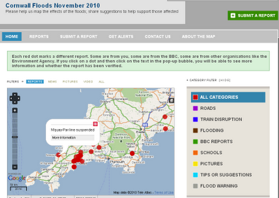
Cornwall Flooding November 2010

Submit a Flooding Report
Cornwall Flooding November 2010 Submit


About This Project

"This is an experimental project created by BBC Cornwall to map reports of the floods. We will add our reports but we'd love you to add your experiences and your tips for helping the community."

You can submit a report by:

a) Sending an email to radio.cornwall@bbc.co.uk

b) Sending a tweet with the hashtags #cornwall #flood or #floods

c) Filling in the form on this site http://cornwallfloods.crowdmap.com/

When you send your reports or comments, they will be put up on the map.


http://cornwallfloods.crowdmap.com/

Labels: , , , ,

16 November 2010

MapQuest Embed Two OSM Editors

MapQuest Embed Two OSM Editors

MapQuest are getting ahead of the rest with an instant online OSM (Open Street Map Editor
MapQuest Potlatch 2 embedded OSM Editors

If you know the area and spot an error on the http://open.mapquest.com sites you can now edit directly using the Potlatch 2 Editor without too much trouble.

Mapquest are pleased with themselves: (and why not?)

"We’ve done it again! Updates are fast and furious on our MapQuest Open sites, powered by OpenStreetMap data. Just this week, we’ve released new edit buttons, ‘send to website’ and ‘right click’ to find the closest thing in your map display.

Our new edit button is really three different edit button or links: below the search result & top right of your map; and edit links that are built into the popup information box. The popup information box allows you to choose which OSM editor you want to use in order to edit the location (or surrounding area). Your two edit tool choices are Potlatch 2 (hosted by MapQuest) or JOSM (known as the “Java OpenStreetMap Editor”). Potlatch 2 uses a GUI user interface for easily making edits whereas JOSM allows you to download chunks of the OSM data onto your desktop to edit and then upload the newly changed data back onto the OSM servers for processing. (Note: be sure JOSM is already installed and running when you click the JOSM edit link.)"

http://blog.mapquest.com/2010/11/11/latest-updates-on-open/

Quite an achievement for both MapQuest and OpenStreetMap

Full Details

http://open.mapquestapi.com/dataedit/

Labels: , , , , ,

12 November 2010

ArcGIS 10 Service Pack 1

ArcGIS 10 (Desktop, Engine, Server) Service Pack 1

ESRI recommends that all ArcGIS 10 customers download and install Service Pack 1 at their earliest convenience, to ensure the highest quality experience when working with ArcGIS 10.

NOTE: If you are using a localized version of ArcGIS (other than Simplified Chinese, Japanese, German, French and Spanish), please contact your local distributor to get the updated language supplement.


ArcGIS Desktop (ArcInfo, ArcEditor, ArcView, ArcGIS Eval Edition)
ArcGISDesktop10sp1.msp
361 MB
ArcGIS License Manager
ArcGISLicenseManager10sp1.msp
5 MB
ArcObjects SDK for the Microsoft .NET Framework
ArcObjectsSDKNET10sp1.msp
264 KB
ArcObjects SDK for Cross Platform C++
ArcReader10sp1.msp
76 MB
ArcGIS Engine Runtime
ArcGISEngine10sp1.msp
105 MB
ArcGIS Server for the Java Platform
ArcGISServerJava10sp1.msp
111 MB
ArcGIS Server for the .Net FrameworkArcGIS Server - GIS Services
ArcGISServerGISServices10sp1.msp
85 MB
ArcGIS Server - Web Applications
ArcGISServerWebApplications10sp1.msp
26 MB
ArcGIS Server Web ADF Runtime

Labels: , ,

09 November 2010

Artography Maps

Artography Maps

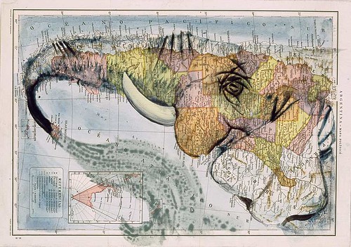
More art into cartography and creating amazing illustrations...

Artography - Dolphin Map

"The word atlas conjures up two very different ways of perceiving the world. The first one that springs to mind is of a book containing a planet-spanning collection of maps, exhaustively descriptive. And then there's Atlas the Greek titan, condemned to carry the weight of the entire world (1) on his shoulders. The latter meaning begot the former: when cartographers started publishing map collections in book-form, they often included in the frontispiece of those collections an image of the world-bearer"


Artography - Elephant Map

Full coverage [Source] including more Artography on The Big Think Blog

Labels: , , , ,

02 November 2010

Isle of Man Maps (OpenStreetMap Series)

Isle of Man Maps (OpenStreetMap Series)

Full Credit goes to Dan Karran

Isle of Man Maps (OpenStreetMap Series)
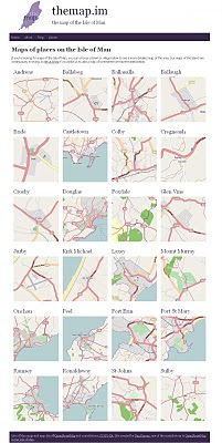
Using OpenStreetMaps to create a series of maps for the Isle of Man. Image via BBC News

From BBC News

For the first time a comprehensive series of Isle of Man maps have been made available online.

The project has taken Manxman Dan Karran around five years so far and is not finished yet.

In the next stage he will add features like woodland, streams, footpaths, parks, tourist attractions and shops.


Isle of Man Maps Places (OpenStreetMap Series)
Isle of Man Places

http://themap.im/places


"The maps got some great coverage with a BBC Isle of Man article, which has generated a good amount of interest in the site. The more people the map is available to, the sooner we can iron out any issues in the map data. There may be the odd typo, things accidentally added in the wrong place, or things that are missing completely, so all feedback is welcome.

For me, building this site is a great opportunity to use Drupal to help promote OpenStreetMap data, using the OpenLayers mapping library (and Drupal module) to display the maps on the site, and I'm looking forward to building the site out further."

http://www.dankarran.com/blog/2010/11/new-maps-of-the-isle-of-man

Original Source
http://news.bbc.co.uk/local/isleofman/hi/people_and_places/newsid_9132000/9132086.stm

Labels: , , ,