->

30 March 2011

Travel Times Paris - OSM

Travel Times Paris - OSM

Find Travel Times in Paris using http://www.isokron.com/


(lower quality Blogger video - but faster)

You can also add an additional point to find the best (fastest) location to meet up half way with a friend.


(Higher Quality Video via You Tube - Slower)

Map Base is Open Street Map and Isocron Mapping

Labels: , , , ,

28 March 2011

Twitter Nano

Twitter Nano

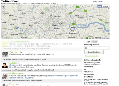
Search by Location (Cross-Hairs) and get real-time tweets from twitter.
Twitter Nano Map

A real-time geolocation Twitter experience Aim the crosshair by dragging the map and get realtime tweets from that location. It's that simple.

Twitter Nano
http://www.twitternano.com/

Source:
http://www.programmableweb.com/mashup/twitternano

Labels: , , , , ,

21 March 2011

Closed Contour SPS Maps

Closed Contour SPS Maps

SPS (Sierra Peaks Section)

Closed Contour SPS Maps


Version 2 of the SPS Map by Closed Contours

New Specs:
  • Whiter glaciers/permanent snow with blue contour lines, talked about this in a previous post.
  • Change forest color depending on density (only in Yosemite and Sequoia/King’s Canyon NP so far). I also mentioned this in a previous post.
  • Non-SPS peak names. Discussed earlier as well.
  • Pass names.
  • Trail names, mostly in the NPs.
  • Removed many bogus ‘lakes’ which were actually mis-characterized permanent snow.
  • Added styling for scree, talus, and meadow/marshes.
  • Changed font for SPS peaks to slightly larger, darker, and italic to set them apart from non-SPS peaks.
  • Not a tile change, but added UTM coordinate display in lower right.

The SPS Maps have 248 peaks in the Sierra Nevada range of eastern California (plus Mount Rose in Nevada). The list is maintained by the Sierra Peaks Section, Angeles Chapter, Sierra Club. The map was designed to encompass all of the peaks on the list with a small buffer around them.


Cartography

Using a Transverse Mercator projection with a central meridian of 120° W, origin latitude of 0°, scale factor of 0.9996, WGS84 ellipsoid, and no false easting or northing. This projection was chosen as a compromise between UTM zones 10 and 11 which unfortunately split the Sierra Nevada vertically right through Lake Tahoe. Here’s the proj.4 string for the projection:

+proj=tmerc +lon_0=120w +k=0.9996 +ellps=WGS84
Data

Data sources:
DEMs are from the USGS NED program. (To generate hill-shade and contours.)
Road data are from TIGER.
Hydrology data are from the USGS NHD program.
Trails data are from the NPS and Forest Service.
Land cover data is from NPS and FRAP.
Buildings are from NPS and Mono County.

Map
http://www.closedcontour.com/

More information
http://blog.closedcontour.com/sps-map/

Full Credit to Dan the Contour Man
http://blog.closedcontour.com/2010/05/23/what-is-closed-contour/

Labels: , , , , ,

15 March 2011

Earthquake Activity & Nuclear Power Stations

Earthquake Activity & Nuclear Power Stations

Earthquake Activity  & Nuclear Power Stations


Earthquakes and Nuclear Power Locations using Google Maps using Fusion Tables with Heat Map. The 'Pacific Ring of Fire' is obvious

http://maptd.com/map/earthquake_activity_vs_nuclear_power_plants/

Source:
http://maptd.com/worldwide-map-of-nuclear-power-stations-and-earthquake-zones/

found by Google Maps Mania comments
http://googlemapsmania.blogspot.com/2011/03/20km-exclusion-zone-on-google-maps.html

Labels: , , , , ,

10 March 2011

OpenEcoMaps

OpenEcoMaps provides free eco-living maps and data from OpenStreetMap

.OpenEcoMaps


OpenEcoMaps Exeter,UK
But why?

There are lots of community groups, councils and companies out there mapping allotments, renewable energy generators, cycle routes and more. But they all suffer from two shortcomings:

1. Duplication - by putting their work into different places, different maps, we're duplicating effort and not benefiting from each other's work. For example, it's common to find several different people all trying to map food growing spaces in the same part of town. Why not share?
2. Tools - not everybody has the tools to map these things, to put the results onto their web site or provide it to their council in the correct format.

OpenEcoMaps encourages people to share all their data in the same place - OpenStreetMap - and makes it easier for you to make use of the results.
How does it work?

OpenEcoMaps takes the data from OpenStreetMap (published under the Creative Commons Attribution-Sharealike 2.0 license), a community that is mapping the whole world and providing all of the information as open data. It takes a fresh data extract every hour and turns it into reusable KML Files, which can easily be displayed on a map.

Map of Exeter includes:
  • Cycling Map
  • Public Transport
  • Aerial Photography
  • Food growing
  • Zero Waste
  • Sustainable Transport
  • Low Carbon Power
http://www.openecomaps.co.uk/map.php?pack=TTE&zoom=1&lon=-3.51&lat=50.72

Source:
http://tom.acrewoods.net/2011/03/09/growing-pains-getting-data-out-of-openstreetmap/

More information:
http://wiki.openstreetmap.org/wiki/OpenEcoMaps
http://www.openecomaps.co.uk/about.php

Labels: , , ,

03 March 2011

Local Government - Open Cycle Journey Planner

Local Government using CycleStreets based on OpenStreetMap OpenCycleMaps
Users can add their own - http://wiki.openstreetmap.org/wiki/Cycle_routes

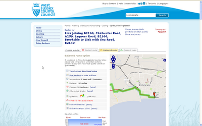
West Sussex County Council Open Cycle Journey Planner


An Excellent addition to West Sussex County Council - Find your quietest journey to work, school or even for leisure.
Features:

  • Turn-by-turn directions
  • Journey time:
  • Distance:
  • Calories:
  • CO2 saving:
  • Quietness-o-meter
  • Route has very busy sections
  • Fly in Google Earth
  • GPS device export (GPX)
  • Elevation Profile.

Try your own journey by bicycle:
http://cyclejourneyplanner.westsussex.gov.uk/

Labels: , , , ,